UNI-DRAGON MINING & DEV. CORP.
Brgy. Bagumbayan, Paracale, Camarines Norte
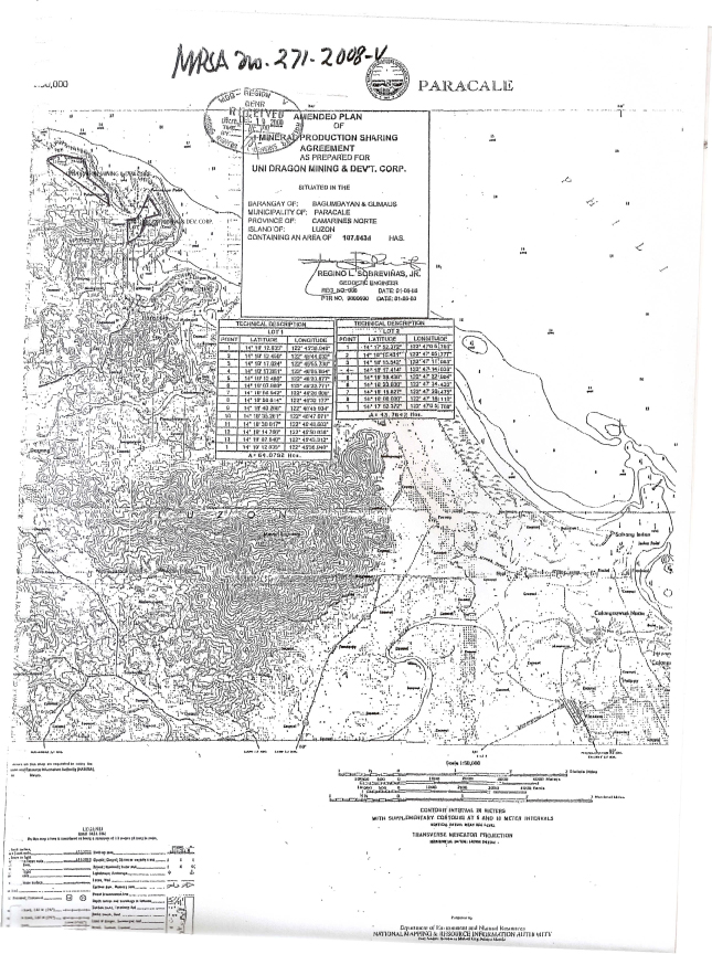
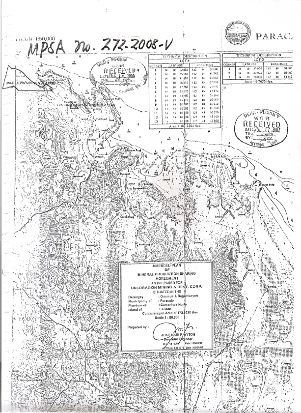
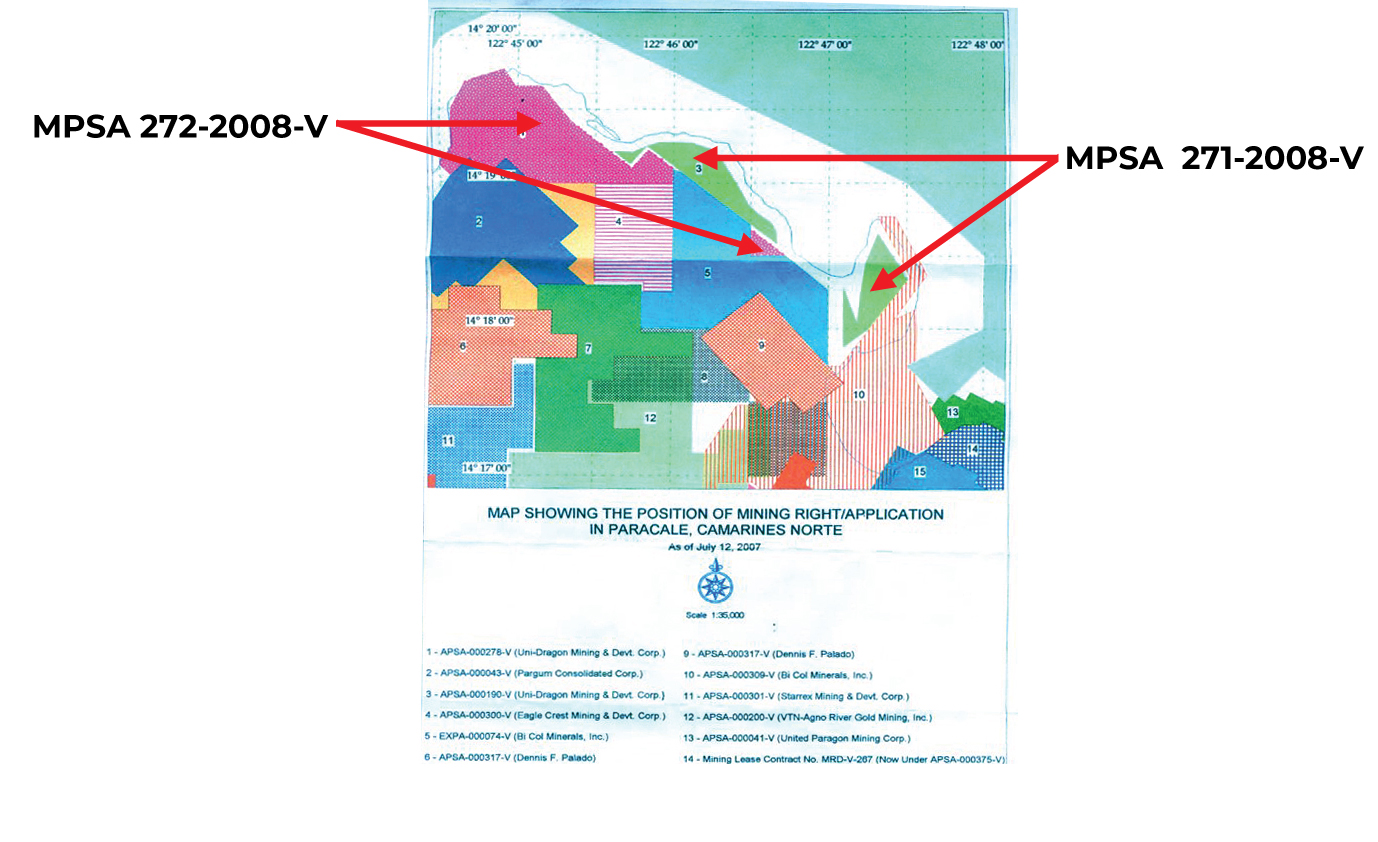
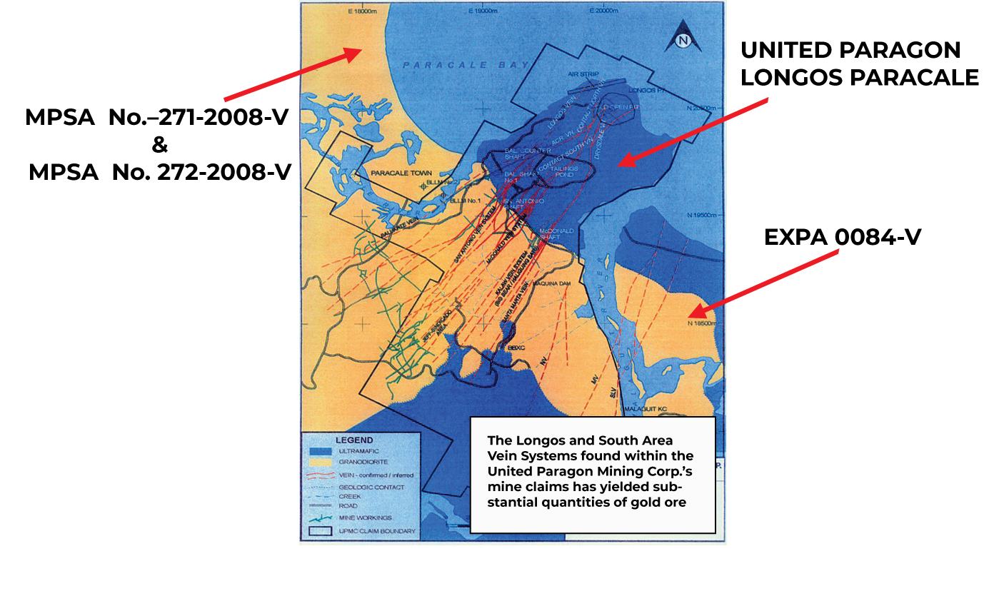
MPSA NO. 271-2008-V AND MPSA NO. 272-2008-V AND PRIVATE PROPERTY
Project Details
Commodity: Gold, Silica, Silver,Uranium, Vanadium, Zinc
Location: Philippines Paracale Camarines Norte
Summary:
Two Claims of Uni-Dragon Mining and Development Corporation (UDMDC).
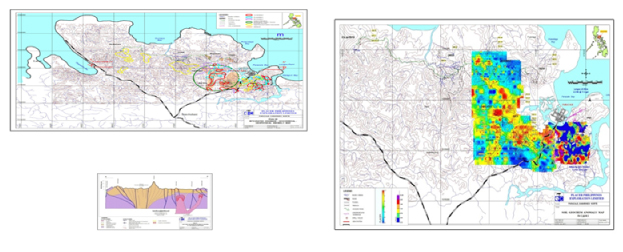
Uni-Dragon Mining and Development Corporation (UDMDC), a duly registered corporation with the Securities and Exchange Commission (SEC) in 1998, has two approved and registered mining claims under MPSA No. 271-2008-V and MPSA No. 272-2008-V covering mining areas of 107.8434 hectares and 173.9329 hectares, respectively, for a total of area of 281.7763 hectares, located at Paracale, Camarines Norte, which were determined to have commercial quantities of deposits of gold, copper, silver and iron sand. Mining operations during the latter part of the Marcos era was, for a time, banned by the Marcos government to make way for the exploration of uranium and scandium.
“The general area offers potential exploration-development target for placer gold deposits and gold rich quartz vein lodes. Silica quartz, associated with gold and magnetite in the alluviums and beach sands, is also a potential quarry resource.”- Samuel Declaro, Geologist
Several preliminary geological assessment and exploration works were done to determine the occurrence of minerals and the quality of mineral deposits in the two claims. It is also worth noting that major geologic study, was also conducted by the Joint United Nations Development Program (UNDP) and Mines and Geosciences Bureau (MGB) in 1987, covering the Panganiban Tablas Area of Camarines Norte, immediately south of the tenement areas. A surface and underground scanning by satellite of the two mining claim areas, as well as the adjacent privately-owned lands of UDMDC, was likewise conducted by NOAH’S ARK, a U.S. company headed by Milton Samuel Taylor, albeit copies of the study and results of the satellite scanning may be obtained through these abovementioned agencies.
Confirmatory geological surveys of the two mining claims and the adjacent 300 hectares of privately-owned lands of UDMDC, were conducted by highly reputable geologists, Samuel Declaro (Lic. No. 000576) and Angel A. Bravo (Lic. No. 0398) in 2005 and 2007, respectively.
The geological survey results show that MPSA 271 and MPSA 272 bear gold reserves, from both placer materials and ore, of 925,076 and 1,708,651 troy ounces, respectively, while the adjacent privately-owned lands of UDMDC was determined to have gold reserves of 8,031,042 troy ounces for a grand total of 10,664,769 troy ounces.
Based on the 2020 goldmarket price of US$ $1,600 per troy ounce, the two MPSA’s which has an aggregate gold reserve of 2,633,727 troy ounces has a total value of US$4,213,963,200. Adding the gold reserves in the adjacent privately-owned lands of UDMDC, the total value would be US$17,063,630,400
An assay laboratory report conducted by the Abra Mining and Industrial Corporation in August 18, 2011 using the AAS Instrumental Method of Analysis of Gold Determination showed an average assay of 51.67 grams of gold per ton of ore. Moreover, an assay conducted by the same laboratory for one alluvial sand sample for gold (Au) and total iron (Fe), indicated 0.45 grams/ton for gold and 55.06 percent for iron.
Presence of small-scale mining activity in the MPSA areas of UDMDC confirms occurrence of gold, yielding fairly high quantities of gold with an average of 8.623 grams of gold per metric ton of ore based on analysis.
It was further determined that both MPSA’s have an aggregate reserves of about 31,950,893 MT of iron sand at depth of 10 feet that is calculated to generate a total net income of about US$288,000,000 for ten years at 2,000 MT per day capacity. Report on Analysis in May, 2011 by the Mines and Geosciences Bureau (MGB) showed Iron, Fe, % at 55.15, Titanium Dioxide, TiO2, % at 2.79 and Copper, Cu, % at 0.10.
At least four relevant evaluation reports and two mine feasibility reports were undertaken during the time when the mining claims were under the aegis of Pedro Trajano (father of Francisco Trajano, the current Chairman of UDMDC):
“Report on the Preliminary Exploration activities in the Placer Gold Claims of Mr. Pedro Trajano Located at Barrios Gumaus and Ngidngid, Paracale, Camarines Norte” by Engr. Virgilio Dela Cruz, 1974.
Geologic Investigation of Six Mining Claims “Henry 1 to 6 in Paracale, Camarines Norte” by Engr. Laureano Abarquez, 1975.
“Mining Project Feasibility Study of Pedro Trajano’s Placer Gold Deposit at Paracale, Camarines Norte” by Engr. Laureano Abarquez, 1978.
“Initial Study of Gold Prospecs in Camarines Norte and Zambales” by Geologist Antonio Dimabuyu (1991)”
Report on the Spot Geologic Investigation of Henry Group of Tenements, Paracale, Camarines orte, Philippines by Samuel Declaro (1997)
Gold Project Feasibility Study of Gumaus Lode and Dredgeable Placer Ground Gold by Engr. H.M. Uriarte & J.C. Espejo
Location and Access:
Paracale, Camarines Norte, Philippines.
Description:
Big Veins occurs as two large parallel quartz veins traceable for 1.8 km trending N25E to NS and dips steeply at 68 to 85E along a NS shear zone at the contact of the Ultramafic and the Paracale Granodiorite . Three possible oreshoots exist and indicated by surface favorable values of 1.4 to 3.6g/t over 0.5 to 4.5 meters of solid quartz veining ( these values are also confirmed by De Leon, 1992). At its northern end lies a possible stringer zone composed of interlacing quartz veinlets from a few centimeters thickness to as wide as .3 meters across an altered zone of 70 to 100 meters width. This zone has possible open pittable potential (Andam, 1985). Underground potential resources would amount to 143,500 tons at 5.5 g/t Au over 2 meter width. The open cut potential was calculated to be 1.13 million tones at 1.5 g/t Au ( Andam,1985) . Assuming a pit design of 30 meter deep pit, a 30% ore discount factor and a 1400 meter strike,this equates to a 35 meter mineralized width ( Motton, 2009). Another set of figures for the Big Vein resource are given as 453,100 tons at 3.47 g/t Au ( De Leon, 1992). This is based on a strike length of 1700 meters, 0.5m width and 205 meter depth, and is therefore an underground scoped resource. Initial metallurgical tests indicate 94.8% Au recovery from a 7.6 g/t Au head grade, while heap leach test showed a 68.8 % gold extraction from 1.4 g/t head grade in a 25 day leach period ( Andam, 1985).
Refer to Big Vein –Anita Map Attachment
Anita Vein is a ENE –trending, ultramafic-hosted vein zone developed in a strike-slip structure. The mapped strikelength is 250 meters. The main quartz vein range from 3-5 meters wide but the mineralized zone is 15-20 meters wide. Metallic minerals are iron oxides- hematite, magnetite, goethite, pyrite and chrome mica. Surface channel samples indicate moderate gold values in outcrops. Gold grades in the main quartz vein range from 1.0 to 2.80 g/t with bulk values between 1.50 to 2.50 g/t. Fluid inclusion petrography indicate the presence of rare type 1 vapor+ liquid inclusion; dominant three-phase type ll inclusions, sub-divided into type llA comprising of vapor+liquid+halite with salinity ranging from 28.06 to 31.04 plus or minus 0.05 wt% NaCl and type llB composed of vapor+liquid+halite+sylvite with estimated compositions of 30 wt% KCl, 20%NaCl and 50 wt % H20; rare type lll inclusions ( vapor+liquid+salt+opaque phase) consisting of 10 to 20 volume% of vapor, a euhedral halite and sylvite daughter crystal which occupy 20 to 40 volume% of the inclusion and a small rounded opaque phase which occupies less than 5 volume% of the inclusion. This opaque phase has been inferred to be chalcopyrite from reflectance observations. Homogenization temperatures range from 250-370 deg. C. High temperature and high salinity measurements and the presence of chalcopyrite daughter minerals of the fluid inclusions suggest the proximity of a juvenile hydrothermal system within the Casalugan area that is most probably related to porphyry mineralization ( Umbal, 1999).
Refer to Anita East Map Attachment
Diamond Veins. These veins occur partly in the central part of the Tigerhills tenement. This is an area where multiple veins exist consisting of 3 to 4 prominent quartz-sulphide veins showing widths from 1.0 to 7.0 meters with an intervening array of quartz stringers and stockworks. This zone is traceable for 1.6 km on strike across 150 meters width. The intensity of the stringers is still being determined ( Andam). These veins trend toward part of the Big Vein prospect and the intervening part must be considered highly prospective. Initial samples indicated 1.4 to 14.1 g/t for the prominent quarta vein members and an average of 1.6 g/t for the intervening stringer zones. Preliminary metallurgical and heap leach test results indicate 92 % Au recovery for straight cyanidization and 70% recovery for a heap leach test in 24 days leach time ( Andam). Assuming 1000m x 150m aerial dimension as potential for bulk low grade possibilities, 30 meter depth range, and 30% ore probability factor, the potential resource would amount to 2.7million tons with a grade of 1.6 g/t Au ( Andam). The Diamond Veins are classified by Bulawan into 3 groups of vein systems as follows:
1. Diamond 1, 2, and 2A
2. Diamond 3 – Salome Vein System
3. Tugos Vein System
Refer to the Diamond Map Attachment
Tugos Vein System. These veins occur partially within the Tigerhills claims, and were worked by the North Camarines mine and the United Paragon mine. Both of these mines are further east of the Tigerhills claims. These veins strike northeast and consist of six to seven vein systems, and include the 111, 201, 301,500, 668, 708 and 721 veins. They can be correlated with the veins in the United
Paragon veins, albeit under different names, such as the Baluarte and San Antonio veins. These veins have considerable lengths of up to 1200m. For the 301 vein, the average gold grade was determined to be 21.1 g/t, while the average vein width was shown to be 0.35 meters ( De Leon, 1992) For the 708 vein, the average width was found to be o.3 meters and the average gold grade was computed at 3.0 g/t ( De Leon, 1992 ). De Leon projects most of the Tugos Vein system at 0.3 meters wide, with grades varying from 4 to 15 g/t Au.
Grid soil geochemistry conducted ( Placer 1998 ) on the Project area successfully defined the vein systems in anomaly maps as to their dimension and and element association.
Additionally, Base Metals Mineral Resources has delineated Supergene type gold deposits which generally occur on the highly argillized areas.
A porphyry copper-gold type deposits were indicated by the Placer Dome, geophysical surveys. The porphyry copper- gold prospects are indicated at the intercepts of Big Vein and Anita Vein at greater than 200 meters depth and at the vicinity of the Diamond, Salome and Tugos Veins.
The search and discovery, exploration and development of the Porphyry Copper –Gold System is programmed to comprise Phase II of Tigerhills’ Exploration Work Program.
Strategic Value. The Paracale district has a coastal location and is serviced by an existing sealed public road system. The national power grid and permanent port facilities. This is a historical mining district with traditional acceptance of mining as a major means of livelihood.
Located at the northeast portion of the project area is the United Paragon Mining Corp. (UPMC), an underground mine which has an estimated resource of 1 Moz gold. The continuation of the high grade vein systems of UPMC is on the adjacent Tigerhills and
Precious Metals Property. If these properties can be consolidated, the combined land position offers the potential for a large gold resource.
Target Concept. A conceptual model formulated to account for the observed gold mineralization within the granodiorite and along the contact with the ultramafic. The model infers two types of mineralization: a syngenetic-type of gold mineralization associated with the emplacement of the Paracale granodiorite during the Cretaceous period into the ultramafic rocks, and a subsequent epigenetic-type of gold mineralization related to later stage diorite intrusions from Miocene to Pliocene ( e.g. Tamisam diorites) along favorable dilational structures. Preferential, though not restricted, gold-rich epi-mesothermal quartz veins and stockworks mineralization peripheral to the ultramafic-granodiorite contact is due to contrasting yield strength between the relatively brittle granodiorite and the more ductile schist/ultramafic rock. This caused vein-fracture networks to flare upward as it abuts into less permeable schist/ulramafic rocks with fracture-channeled migrating mineralized fluids depositing at the up-dip portion of the lithologic boundary or pounding within antiformal structures. Occurrence of vein breccias and sheeted vein structures suggest multiple hydrothermal/ mineralization events. Fracture-vein networks appear to be controlled by WNW sub- parallel, left-stepping, left lateral strike-slip faults transecting minor NE trending faults and fractures that become the loci and conduits for post-Paracale granodiorite intrusions and migrating gold-bearing hydrothermal solutions.
Mineral Resource Inventory
Target Resource within MLC-507
PROSPECT
Anita West Ore (t)
424,807 Au g/t
1.65 Au oz
24,630 Au g
700,932
Big Vein North 77,580 2.30 5,749 178,434
Big Vein Central 37,380 3.53 4,243 131,951
Eluvial 474,836 0.80 12,148 379,869
Diamond 123,579 2.60 10,278 321,305
Teepee 40,977 2.00 2,648 81,954
Tugos Veins 1,188,000 10.80 412,553 12,830,400
TOTAL
2,367,159
6.18
470,252
14,624,845
A target resource potential of some 2.3 million tons at 6 g/t Au for 470,000 ounces from these quartz vein deposits is inferred from scoping studies based on the work by Andam (Benguet Corp.) and De Leon ( MGB for BMMR). Motton 2010
Potential Resource Estimates
Bulawan ( 2007) tabulated as follows:
Area Tonnage Ave. Grade Oz. Au
Big Vein –Anita 1,686,466 2.01 g/t 109,121
Diamond – Salome 1,188,717 10.82 g/t 424,968
Potential Resource External and Adjacent to MLC 507
Resource Scoping Study, De Leon
Area Tonnage Ave.Grade Oz. Au
Tugos Veins 1,346,408 11.69 g/t 470,252
Drilling Program Summary
Year Company No. of Holes Metereage
1987-88 Benguet 6 564.00
1996-97 Base Metals 15 1,529.85
1997-99 Placer Dome** 40 4,872.00
2006-07 Bulawan 33 2,853.66
94 9,254.51
Within the Tenement MLC- 507 78
Benguet Drilling at Big Vein and Anita East Placer Dome Drillholes, RC scout holes**
Distribution of Drillholes by Prospects
Company BigVein/Anita/ Coloran/Casalugan/Magsimalo/Tinga/ Omega/Sta. Barbara
Tugos
Benguet 2 4
Placer Dome 7 3 15 3 3 3 2 4
Base Metals 11 4
Bulawan 24 8
Summary of Proposed Drill holes
Area No. of Drill Holes Meterage
Big Vein – Anita* 20 4,000 m
Diamond Veins ** 13 2,600 m
Refer to Big Vein- Anita Map* Diamond Vein **
TIMETABLE
In summary, the immediate program is to complete the drilling program on these two open-pit mining areas (Big Vein- Anita and Diamond Vein ) where some 33 drill holes have been programmed for a total of 6,600 meters.
Previous drilling performance is at 25-30 meters per day per drill rig . Completion time of the drilling program will depend on the number of drills used simultaneously at a given time.
Tabulated below are the technical programs, studies and plans that are pre-requisites, and /or are aids in the conduct and Declaration of Mine Project Feasibility Study. The preparation time in the conduct of each are tabulated separately . When conducted in the prescribed order, total preparation time is estimated at 3- 4 months.
1.Drilling Program
Area No. of DH Total Depths Completion time
Big Vein- Anita 20 drill holes 4,000 meters 4.5 months
Diamond Vein 13 drill holes 2,600 3.0
2.Negotiation with Claim Owners of Adjacent Properties 2.0 mos.
3.Ground Verification Survey of Claim Boundaries , 2.0 mos.
Drill hole,Trenches and Vein location
4.Declaration of Mine Project Feasibility :
( Technical Programs, Studies, and Plans ) Preparation time
1.Ore Sufficiency Determination 2 wks
2.Mineral Resource Report 2 months
3.Mine Feasibility Study 2 mos
4.3 Year Work Program 1.5 mos
5.Environmental Impact Study ( to secure an ECC ) 2 mos Environmental Compliance Certificate
6.Environmental Protection and Enhancement Program 2 mos
7.Final Mine Rehabilitation /Decomissioning Plan 2 mos.
8.Social Development and Management Program 2 mos
9.Safety and Health Program 2 wk